22 Davisland Avenue
Wilton, NSW 2571
Neighbourhood & everyday essentials
Explore around Wilton, from school days to weekends.
Find schools, playgrounds and children’s classes. Browse by age to plan school days and weekends.
Area figures
- residents (ABS, June 2024)
- 59,782
- children aged 0–14
- 13,070
- schools
- 15
- parks & libraries
- 24
- kids’ activity providers listed
- 15
Most-listed activities: Art Centre, Gymnastics, Karate
Population figures: Australian Bureau of Statistics
Explore local libraries, community spaces, schools and council programs across the wider area.
Parks, playgrounds & public spaces
Things to do near this home
Explore nearby play centres and family attractions from the directory. Check ages, entry prices and opening hours with the venue.
Find more ideas by age, budget and indoor or outdoor setting on Things to do. Dated events are in What’s on. See what’s on
Discover local guides & family ideas
Read local family guides and practical articles as you explore life around this home.
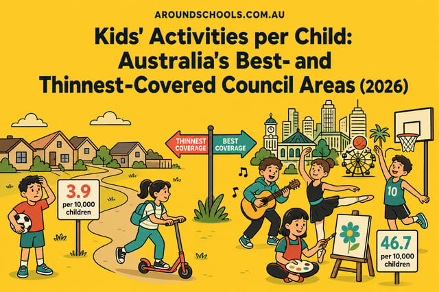
Kids' Activities per Child: Australia's Best- and Thinnest-Covered Council Areas (2026)
Across Australia's big council areas, the AroundSchools directory lists a median of about 10 kids' activity providers for every 10,000 children — but in Melbourne's Wyndham it is 3.9, and in the City…
Read more →
Most Livable Suburbs in New South Wales for Families (2026)
Sydney lists more kids' activities in our directory than any other suburb in NSW. This page ranks NSW suburbs by how much a family moving there could actually do with their kids, then adds what else…
Read more →Everyday essentials & getting around
Open the map to choose a destination and check journey times from this address. Walking routes, step-free access and travel times have not been verified.
Flood & development checks
Property-specific flood risk and announced developments have not been verified. Search this address in the official maps and ask the council for current flood information.
Source: AroundSchools directory. Distances are straight-line distances, not walking routes. Confirm facilities on the linked detail pages. Directory update dates are not supplied for this summary.
Property Details
282 m²
House
RESIDENTIAL
Upcoming Events Nearby

What's Nearby



Nearby Schools

Wilton Public School
11 Greenbridge Dr, Wilton NSW 2571, Australia

Douglas Park Public School
111 Camden Rd, Douglas Park NSW 2569

Picton High School
480 Argyle St, Picton NSW 2571

Tahmoor Public School
Bronzewing St, Tahmoor NSW 2573

St Anthony's Primary School - Picton
Menangle Street, Picton NSW 2571 Australia

Picton Public School
Lumsdaine St, Picton NSW 2571
Nearby schools do not imply enrolment eligibility. Confirm catchments, year levels and childcare availability directly with the provider.
Nearby Properties
Recently sold nearby
Homes that have sold close to this address. We don’t show sale prices.
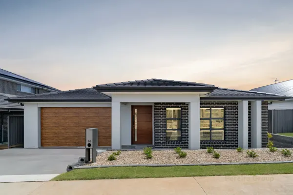
Wilton, NSW 2571
Land Size: 480 m²
Property Type: House
Listing Type: Residential
Status: Active
Summary: Immaculate Contemporary Home in Prime Location
Description: Presenting an exceptional opportunity in one of Wilton's most desirable neighbourhoods, this modern, brand-new residence delivers refined family-focused design and low-maintenance luxury living. With no expense spared, this executive residence will suit even the most discerning buyer. A rare offering with two master suites, both with ensuites and walk in wardrobes, two further generously proportioned bedrooms with built in wardrobes. Key Features: - Four large bedrooms including a master suite with walk-in robe and private ensuite - Two additional designer bathrooms fitted with floor-to-ceiling tiles, matte-black fixtures and a freestanding bath in the main - A sleek designer kitchen featuring black cabinetry, stone benchtops, large island breakfast bar and walk-in pantry - Spacious open plan living and dining area, plus separate theatre/media room for flexible living - Covered alfresco with tiled flooring, ceiling fan and built-in cabinetry with sink, overlooking a private level backyard - Ducted air-conditioning, LED lighting, high ceilings and engineered timber flooring throughout - Double lock-up garage with internal access, ample storage and low-maintenance landscaping Location Highlights: - Wilton Public School - 2.1km - Teas & Greens Cafe - 2.0km - Woolworths Metro Wilton Plaza - 2.0km Situated in a quiet, family-friendly street, you're just minutes from local parks, schools, recreational facilities and future amenities. This property offers the perfect blend of convenience and tranquillity. *All locations are approximate distances. *Century 21 Pereira Group believes all information contained herein is accurate at the time of advertising. However, we encourage interested parties to conduct their own enquiries.
Agent: Shaun Pereira - shaun.pereira@century21pg.com.au - 0416227117
Agent: Madeline Aziz - madeline.aziz@century21pg.com.au - (02) 4647 9727

Wilton, NSW 2571
Property Type: Vacant Land
Listing Type: Residential
Status: Active
Summary: Wilton Perfect lot Just Listed
Description: Looking to build your dream home? This an excellent opportunity to build your dream home or investment property. This peacefully placed block is located in the highly sought after Wilton Green. Nestled in the heart of Wilton, this picturesque community has been thoughtfully designed to harmonise with its stunning natural surroundings. Plus luxury of park lands, lakes and a golf course. Estimate Registration: Q3 2025 Lot Features: -Land size: 315 -Frontage:12.6 -Rear:12.6 -Left boundary: 25 -Right boundary 25 -Garden North facing Key Features: - Easy access to the M7 and M5 motorways - Easy access to Badgerys's Creek Airport - Easy access to Wollongong - Local shops, parks and schools **Disclaimer: C21 OZGROUP PROJECTS have made every effort to ensure all information is true and correct at the time of publishing. Please note changes may be made that could impact the accuracy of this information. C21 OZGROUP PROJECTS encouraging all parties to seek their own legal and financial counsel.
Agent: Nancy (Yuan Yuan) Zhao - Nancy.zhao@c21ozgroupprojects.com.au - 80416983

Wilton, NSW 2571
Land Size: 501.4 m²
Property Type: Vacant Land
Listing Type: Residential
Status: Active
Summary: Create your dream home In Wilton!
Description: Looking to build your dream home? This an excellent opportunity to build your dream home or investment property. This peacefully placed block is located in the highly sought after Wilton Green. Nestled in the heart of Wilton, this picturesque community has been thoughtfully designed to harmonise with its stunning natural surroundings. Plus luxury of park lands, lakes and a golf course. Estimate Registration: Q4 2025 Land size: 501.4 m2 Key Features: - Easy access to the M7 and M5 motorways - Easy access to Badgerys's Creek Airport - Easy access to Wollongong - Local shops, parks and schools **Disclaimer: C21 OZGROUP PROJECTS have made every effort to ensure all information is true and correct at the time of publishing. Please note changes may be made that could impact the accuracy of this information. C21 OZGROUP PROJECTS encouraging all parties to seek their own legal and financial counsel.
Agent: Nancy (Yuan Yuan) Zhao - Nancy.zhao@c21ozgroupprojects.com.au - 80416983
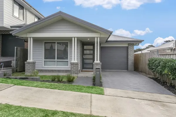
Wilton, NSW 2571
Land Size: 250 m²
Property Type: House
Listing Type: Residential
Status: Active
Summary: Close & Comfortable!
Description: Do not miss your chance to secure this ideal first home or investment in the heart of Bingara Gorge situated just moments away from the shops and School! On offer are three bedrooms, main with a walk-in robe and ensuite and other two with built-in robes, as well as a modern main bathroom with separate bath and shower. This home features an open plan living and dining area atop of a floating floor. The kitchen is impressive with gas cooking, 900mm oven, dishwasher, island bench with breakfast bar and a walk-in pantry. Additionally, this property comes with ducted air conditioning, European laundry, down lights and internal access to the garage. Outdoors the property comes with a single garage with single car space in front, alfresco at the back and a small low maintenance backyard. This property is situated on 250m2 in the fast growing Bingara Gorge, Wilton, and is sure to attract plenty of attention from first home buyers and investors, so make sure you don't miss out and book an inspection today!
Agent: Erik Bjorklund - erik@century21argylerealty.com.au - 4677 2155
Agent: Madison Bassili - madison@century21argylerealty.com.au - 02 4677 2155
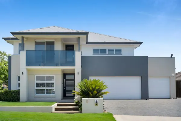
Wilton, NSW 2571
Land Size: 595 m²
Property Type: House
Listing Type: Residential
Status: Active
Summary: Luxury family living in the heart of Wilton
Description: Positioned within the prestigious Bingara Gorge Estate, this exceptional residence exceeds the standard contemporary family living, combining scale, sophistication and thoughtful design across two expansive levels. Showcasing five generous bedrooms, four and a half luxurious bathrooms and a triple-car garage, the home has been meticulously planned to accommodate large families, multigenerational living and effortless entertaining. At the heart of the home, an expansive gourmet kitchen impresses with quality finishes, extensive bench space, a full butler's pantry and additional walk-in pantry, seamlessly connecting to the open-plan dining and leisure zones. Multiple living areas, both upstairs and downstairs, provide flexibility for families at every stage, while a dedicated home theatre delivers the ultimate private cinema experience. Upstairs, the master suite is a true retreat, featuring a luxurious ensuite with floor-to-ceiling tiling, dual vanities, walk-in robes and direct access to a private balcony. Adjoining the master suite is a versatile enclosed space, currently set up as a private gym, offering the perfect balance of wellness and convenience within the home. All additional bedrooms are generously proportioned, many with en-suites, ensuring comfort and privacy for family and guests alike. Designed for year-round enjoyment, the home extends outdoors to a covered alfresco area and resort-style spa, creating an inviting setting for entertaining or unwinding in complete privacy. Located moments from Bingara Gorge Golf Course, local cafés, parks and walking trails, and within easy reach of Wilton village amenities and the Hume Motorway, this is a rare opportunity to secure a premium lifestyle home in one of the area's most sought-after addresses. Key Features: > Five oversized bedrooms, most with ensuite access > Ducted Air (4 zones) > Irrigation with timer > Large outdoor entertaining with pizza oven > Inbuilt BBQ and space for your own beer taps > Provision for pool (STCA) > Four and a half luxury bathrooms with floor-to-ceiling tiling > Master suite with walk-in robes, ensuite & private balcony > Private gym space adjoining the master suite > Multiple living zones across both levels > Dedicated home theatre room > Expansive gourmet kitchen with butler's pantry & walk-in pantry > Covered alfresco entertaining with spa > Triple-car garage with internal access > Located in the prestigious Bingara Gorge Estate with access to community amenities, including the country club that is expected to open in April NOTE: In preparing this, we have used reasonable endeavours to provide information that is true, however, it is provided on the basis that readers will be responsible for making their own assessment of the information and are advised to verify all relevant representations, statements and information. All photographs and images are representative only, for marketing purposes.
Agent: Shane Mackaway - shanemackaway@stonerealestate.com.au - 02 4655 3000
Agent: Bennett Parkinson - bennettparkinson@stonerealestate.com.au - 02 4655 3000
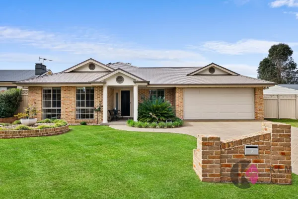
Wilton, NSW 2571
Land Size: 1103 m²
Property Type: House
Listing Type: Residential
Status: Active
Summary: Stylish Family Living with Entertaining Excellence
Description: Step into this beautifully presented 5-bedroom brick veneer family home, perfectly designed for comfort, style, and functionality. With both formal and informal living areas, this spacious, light-filled residence caters effortlessly to modern family life. At the heart of the home lies a stunning kitchen that will be the talking point among family and guests alike. Thoughtfully positioned to overlook all angles of the home, it features a breakfast bar, light-filled windows with a servery option, a double sink, and sleek modern appliancesblending practicality with contemporary style. Enjoy year-round comfort with a slow combustion fireplace for cozy winter nights and ducted air conditioning throughout for summer ease. The home truly shines when it comes to entertaining. Choose between two undercover pergola areasideal for BBQs or relaxed outdoor diningor unwind in the open paved area overlooking a sparkling inground pool. Featuring a shallow zone for kids and an elegant water feature, this backyard oasis is perfect for making lasting memories. Additional features include a double lock-up garage under the main roof and convenient side access to an oversized double shedideal as a man cave, workshop, or extra storage. This is more than just a homeit's a lifestyle. Don't miss your chance to inspect this impressive family haven.
Agent: Kate McClelland - kate@klmpropertygroup.com.au
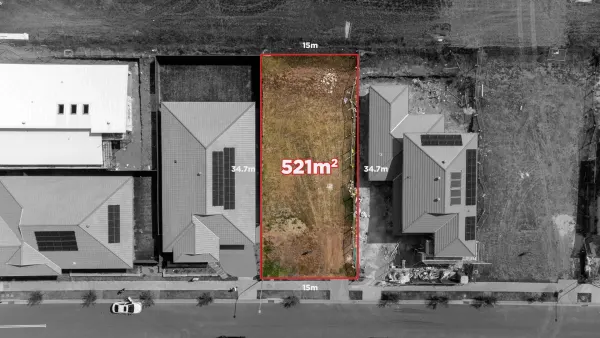
Wilton, NSW 2571
Land Size: 521 m²
Property Type: Vacant Land
Listing Type: Residential
Status: Active
Summary: REGISTERED & READY FOR YOUR DREAM HOME !
Description: Discover an exceptional opportunity to secure a premium 521sqm parcel in the thriving Panorama Estate of North Wilton. Perfectly positioned on the high side of the street & in a family-friendly estate, this block offers the ideal foundation to create your dream home or savvy investment. With a generous 15m frontage & 34.7m depth, the block provides outstanding flexibility for a wide range of modern home designs, including a spacious single or double-storey layout, side access, or extra yard space for the kids. It also appeals to investors with ample land area for a home & granny flat (S.T.C.A) Surrounded by quality homes, parklands, & premium amenities, this parcel of land captures the very best of community living. Set within a master-planned estate renowned for its open green spaces, golf course access, & family-friendly charm, it offers an unbeatable lifestyle opportunity in one of Wilton's most desirable pockets. Property Highlights: • 521sqm of prime, registered land • Wide 15m frontage - great street presence • Depth of 34.7m - ideal for larger floorplans • Set within a fast-growing, master-planned community • Close to local parks, schools, transport links, Bingara Gorge Golf course, Wollongong CBD and future town centre. Whether you're building your forever home or securing a smart investment in one of NSW's fastest-growing regions, this block offers unbeatable potential.
Agent: Sam Inzitari - sam@uapg.com.au - 0414487105
Agent: Michael Inzitari - michael@uapg.com.au - 0404754141
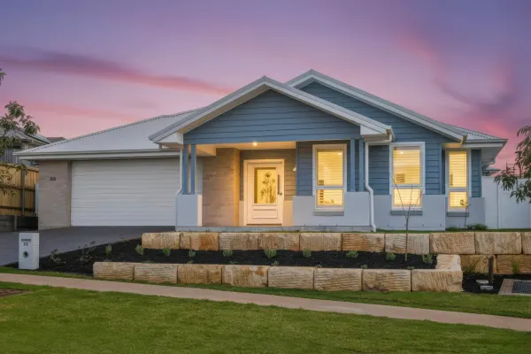
Wilton, NSW 2571
Land Size: 668 m²
Property Type: House
Listing Type: Residential
Status: Active
Summary: Your Forever Family Home Starts Here
Description: Opportunities like this are exceptionally rare. Offered in immaculate, display-home condition, this residence showcases premium craftsmanship, meticulous detailing, and a level of turn-key presentation that is simply unmatched. Whether you're an investor seeking secure, effortless income or a buyer wanting a move-in-ready home built to the highest standard, this property stands in a class of its own. At the heart of the home is a breathtaking designer kitchen the true centrepiece of the residence. Every element reflects quality: a walk-in butler's pantry, Fisher & Paykel appliances, and luxurious 40mm Caesarstone benchtops. Designed for both beauty and functionality, it flows seamlessly into the light-filled open-plan living and dining area, thoughtfully oriented to the north to capture all-day natural light. Privately positioned at the front of the home, the master suite offers a premium retreat experience. Featuring a striking VJ panel wall, plush carpets, and a custom walk-in wardrobe complete with a built-in makeup station, it delivers refined comfort at every turn. The ensuite elevates the experience further with floor-to-ceiling tiles, underfloor heating, a double vanity, and a separate WC a showcase of quality and design excellence. Purposefully planned, the split-level layout creates distinct separation between the parents' retreat and children's wing, enhancing privacy, tranquillity, and everyday liveability. The second bedroom, complete with its own walk-in wardrobe, makes an ideal teenager's retreat or luxurious guest suite, while two additional bedrooms offer built-ins and picturesque garden views through expansive picture windows. Every aspect of the home reflects display-home attention to detail from the finishes to the carefully considered zoning of living spaces. A dedicated media room adds versatility and can easily function as an office or fifth bedroom. Step outside and the display-home presentation continues. The landscaped yard has been completed with the same level of intention and craftsmanship, delivering a space that is fully finished, functional, and ready to enjoy from day one. Premium property features include: Impressive entry with feature VJ panelling and built-in bench seat Elegant plantation shutters throughout High-end kitchen with walk-in pantry, Fisher & Paykel appliances, and 40mm Caesarstone benchtops Whole-home water filtration system delivering purified water to every tap Light-filled open-plan living and dining with ideal northerly aspect Versatile media room suitable as an office or fifth bedroom Underfloor heating in both the main bathroom and ensuite for year-round luxury Main bathroom with separate WC for added practicality Tiled undercover alfresco, perfect for stylish outdoor entertaining Oversized double garage with epoxy flooring-ideal for storage, a home gym, or workshop Fully landscaped yard with side access and tiered garden beds 6.6kW solar system for enhanced efficiency New, cohesive fencing offering both privacy and a premium finish For more information or to arrange a private inspection, please contact Isabella McMahon on 0476 266 765 Disclaimer: Please note all information contained herein has been provided by third-party sources such as owners, solicitors, and developers. Whilst we endeavour to confirm all information provided, we cannot guarantee its accuracy. Any person using this information provided should rely on their own enquiries for verification.
Agent: Isabella McMahon - isabella@fnbowral.com.au - 4861 4861
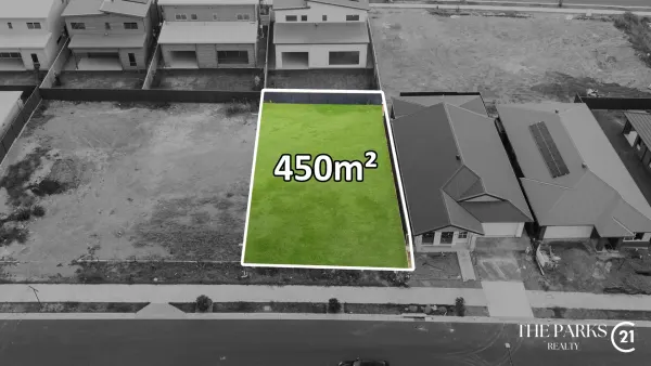
Wilton, NSW 2571
Land Size: 450 m²
Property Type: Vacant Land
Listing Type: Residential
Status: Active
Summary: Build Your Dream Home in the Exclusive Bingara Gorge Estate
Description: Welcome to an exceptional opportunity to create your dream home within the prestigious Bingara Gorge Estate in Wilton. Set on a 450m² parcel of land, this vacant block offers the perfect foundation to design a home that reflects your lifestyle—surrounded by quality residences, lush greenery, and resort-style amenities. As a Bingara Gorge resident, you'll enjoy exclusive access to the Bingara Gorge Country Club, featuring a private gym, swimming pools, tennis courts, and golf facilities, all designed to promote relaxation, recreation, and community connection. It's more than just a place to live—it's a lifestyle defined by leisure and luxury. Wilton itself is a rapidly growing township that blends the serenity of countryside living with the convenience of city accessibility. Located within the picturesque Wollondilly Shire, Bingara Gorge provides a peaceful escape from the city while keeping you well-connected—just minutes from the Hume Motorway for easy access to Sydney, Wollongong, and the Southern Highlands. With nearby schools, parks, local shops, and the natural beauty of the region at your doorstep, this is the ideal place for families, professionals, and downsizers seeking a premium community environment. Secure your piece of Bingara Gorge today and start planning a lifestyle where every day feels like a getaway.
Agent: Sam Kindo - sam.kindo@century21.com.au - (02) 9610 9444
Agent: Ben Palmerone - ben.palmerone@century21.com.au - 02 9610 9444